
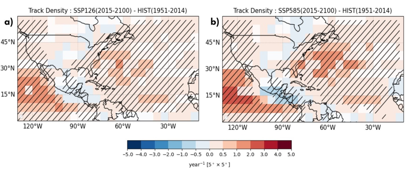
Figure 1 from Lele et al. (2026). Multi-Model Mean of track density change in the North Atlantic, calculated between future and historical periods for SSP1-2.6 (a) and SSP5-8.5 (b). Stippling shows regions with statistically significant differences at p=0.05 based on a two-sided Student’s t-test from the 12-model, 10-track ensemble and 40-intensity ensemble.
This blog post and the “Deep Dive” podcast, created by Google Notebook, are based on “Future redistribution of North Atlantic tropical cyclone risk in two contrasting CMIP6 scenarios” by Lele et al. (2026).
Lele et al. (2026) utilized the Columbia HAZard model along with 12 global climate models from CMIP6 to investigate how future North Atlantic tropical cyclone risks might evolve under contrasting greenhouse gas emission scenarios, specifically SSP1-2.6 and SSP5-8.5. Their findings reveal a distinct regional contrast in storm landfalls along the United States coastline, demonstrating that tropical cyclone frequencies will decline along the Gulf Coast—including Texas—while increasing along the Southeastern U.S. coast throughout the 21st century. This spatial redistribution is driven primarily by large-scale circulation shifts and vertical wind shear patterns resembling an El Niño–like climate state, rather than being determined strictly by the overall magnitude of global warming. Consequently, the study emphasizes that regional climate adaptation strategies must account for specific geographical warming patterns and circulation changes rather than relying solely on basin-wide projections.
The Hurricane Paradox: Why Global Warming Won’t Hit Every Coastline Equally
A common, intuitive assumption in climate discussions is that a hotter planet automatically leads to a uniform increase in hurricanes crashing into every coastal city. The logic seems straightforward: warmer ocean waters should act as a universal fuel source, powering more frequent and destructive storms along every reachable shore.
However, for coastal residents, urban planners, and climate adaptation experts, relying on broad global-mean temperature projections creates a dangerous blind spot. Global averages fail to capture local and regional realities, where shifting atmospheric circulation can completely redefine local risk. To address this challenge, researchers at Columbia University utilized the Columbia HAZard (CHAZ) model to downscale climate projections from 12 CMIP6 global climate models, comparing hurricane risk across two contrasting future pathways: a low-emissions scenario (SSP1-2.6) and a high-emissions scenario (SSP5-8.5).
The findings reveal a striking counter-intuitive reality: future hurricane hazard along the U.S. coastline is driven far more by where ocean warming and atmospheric changes occur (spatial patterns) than by how much the global average temperature increases.
1. The Great Coastline Divide: Gulf Risk Drops while the Southeast Braces for Impact
Rather than a uniform increase in storm strikes across American shores, future projections reveal a major geographic redistribution of hurricane hazard. Landfalling tropical cyclone (TC) frequency is projected to decrease along much of the Gulf Coast—specifically impacting Texas—while significantly increasing along the Southeastern U.S. coast.
This divergence is not a distant end-of-century scenario; it is detectable in climate models as early as the near-term epoch (2030–2050), accelerating through mid-century (2060–2080) and into late-century (2080–2100). Crucially, this regional split persists across both low-emissions (SSP1-2.6) and high-emissions (SSP5-8.5) pathways.
The scientific consensus across the models is remarkably robust. Under the high-emissions SSP5-8.5 scenario, 100% of the downscaled climate models (12 out of 12) agree on the sign of this positive risk divergence between the Southeast and Texas coasts by late-century. Even under the low-emissions SSP1-2.6 scenario, 75% of models (9 out of 12) project the same coast-to-coast split.
“Our results suggest that changes in regional TC risk depend less on the overall amount of global warming than on its spatial pattern, and that future changes in the pattern of tropical Pacific climate change are particularly important to North Atlantic TC activity and U.S. TC risk.”
2. The Global Average Delusion: Why Patterns Beat Degrees
Evaluating coastal storm risk through global or basin-wide metrics can significantly mislead local adaptation planning. In the North Atlantic, a net zero or minor change in overall basin-wide storm counts can easily disguise massive, offsetting local shifts beneath the surface—such as fewer storms entering the Gulf of Mexico balanced by more storms striking the Atlantic seaboard.
Thermodynamically, a tropical cyclone’s Potential Intensity (PI)—the theoretical speed limit a storm can reach—does not respond to uniform global temperature spikes alone. A hurricane acts like a thermal heat engine, running on the temperature difference between the local ocean surface and the broader tropical upper atmosphere. Consequently, PI responds to local sea surface temperatures (SST) measured relative to the tropical mean. Because surface warming is spatially uneven across the globe, sub-basin changes in storm capacity can be far larger or smaller than global average headlines suggest.
Importantly, this regional coastline split is resilient to methodological nuances. While absolute basin-wide storm counts vary depending on whether Column Relative Humidity (CRH) or Saturation Deficit (SD) is used in moisture index formulations, the relative coastline split—a surge in Southeastern risk paired with a decline along Texas—is 100% robust across both moisture parameterizations. For policy and insurance analysts, this means the projected redistribution of coastal hazard is a rock-solid feature of model physics.
3. The Atmospheric Shredder: How Shifting Winds Protect Texas but Threaten the Atlantic Coast
What physical mechanism reshuffles these storm pathways? The dominant driver is vertical wind shear—the difference in wind speed and direction between the lower troposphere (850 hPa) and upper troposphere (250 hPa). Wind shear acts as an environmental storm killer: differential winds physically tear a cyclone’s structure apart, disrupting its vertical heat engine and tilting its warm core away from its moisture supply.
Under future climate projections, large-scale atmospheric circulation reorganizes vertical wind shear and steering flows in ways that fundamentally alter storm survival:
- The Atmospheric Shredder over the Gulf: Vertical wind shear increases substantially over the western Atlantic, Caribbean, and Gulf of Mexico. This enhanced shear actively suppresses tropical cyclone formation and shreds storms attempting to track westward toward Texas.
- The Conducive Runway to the Southeast: Conversely, vertical wind shear weakens across the central and eastern Main Development Region (MDR) of the tropical Atlantic. This creates a smooth, undisturbed runway for storms to form, organize, and intensify as they head toward the Southeastern U.S.
- Altered Steering Currents: Synoptic steering winds show enhanced easterly flow across the tropical Atlantic. These steering anomalies favor pathways guiding storms formed in the MDR straight toward the Southeastern seaboard, while reducing the likelihood of storms progressing into the western Caribbean and Gulf.
To pinpoint the exact causes of this coastline split, researchers performed an origin decomposition analysis. For the Southeastern coast, the late-century surge in landfalls is driven almost entirely by an increase in storm genesis within the MDR and subtropical Atlantic (+18.6% under SSP1-2.6; +12.8% under SSP5-8.5), with minimal contribution from track changes (-1.0% / -1.6%).
For Texas, the decline under high emissions (SSP5-8.5) is a double-whammy: local storm genesis drops by -14.9%, while adverse steering track pathways reduce landfalls by another -13.6%. Under low emissions (SSP1-2.6), a slight increase in local Texas genesis (+6.0%) is completely offset by unfavorable steering tracks (-7.6%), keeping net landfall changes near zero (-1.4%).
4. The Emissions Paradox: Extreme Warming Suppresses Gulf Hurricanes Even Further
The interaction between greenhouse gas emission scenarios and local hurricane risk presents a striking paradox. End-of-century (2080–2100) global mean warming relative to the 1995–2014 baseline is projected to be 1.23 ± 0.83°C under the low-emissions SSP1-2.6 pathway, compared to a staggering 3.99 ± 1.59°C under the high-emissions SSP5-8.5 pathway. Yet, landfalling storm frequency along the Texas coast drops more under severe warming than under low warming.
This occurs because higher greenhouse gas concentrations intensify the atmospheric circulation response in climate models, further cranking up the protective vertical wind shear over the Gulf of Mexico. The more the climate warms, the harder the atmospheric “shredder” blows across the western Caribbean and Gulf.
Conversely, for the Southeastern U.S., severe warming compounds hazard levels where shear relaxes. Under SSP5-8.5, shortened return periods mean major landfalling hurricanes will recur more frequently, amplifying coastal threat where atmospheric conditions remain favorable.
5. The Pacific Wildcard: Model Projections vs. Real-World Pacific Trends
While CMIP6 models show high consensus on these Atlantic shear changes, a major scientific wildcard lies thousands of miles away in the tropical Pacific Ocean. The projected Atlantic wind shear patterns depend heavily on climate models simulating an “El Niño-like” shift in the Pacific’s mean state—characterized by weakened east-west sea surface temperature gradients.
Here, researchers encounter a critical plot twist: real-world historical observations over recent decades show the tropical Pacific behaving more like “La Niña,” with cooling waters in the eastern equatorial Pacific and strengthened temperature gradients—standing in direct contrast to model projections.
If the real ocean continues to follow historical La Niña-like trends rather than model projections, Atlantic wind shear patterns could evolve differently. However, the study’s primary lesson remains unchanged: whether models or historical observations win out, local hurricane hazard is ultimately dictated by shifting ocean warming patterns and regional wind shear, not by uniform global headline temperatures.
Rethinking Coastal Resilience for the 21st Century
As 21st-century climate change unfolds, urban planners, emergency managers, and insurance risk modelers must abandon one-size-fits-all global assumptions. Building resilient infrastructure requires recognizing that warming impacts will not manifest uniformly across every mile of coast, but will follow geographically specific risk trajectories driven by regional atmospheric engines.
The storm map of tomorrow will not be a simple, amplified clone of yesterday’s map, but a radically reshuffled landscape of risk. How should coastal communities, property insurers, and federal policymakers adapt their long-term infrastructure and capital allocations when future storm pathways alter the geography of coastal hazard?
Lele, R., Sobel, A. H., Lee, C.-Y., Camargo, S. J., Tippett, M. K., Kelly, P., et al. (2026). Future redistribution of North Atlantic tropical cyclone risk in two contrasting CMIP6 scenarios. Geophysical Research Letters, 53, e2026GL123424. https://doi.org/10.1029/2026GL123424


Leave a comment