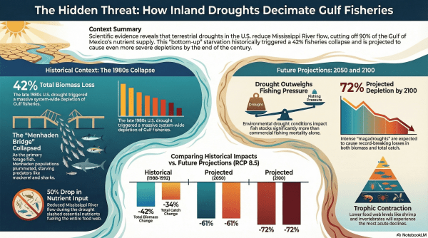
Java-Sumatra Niño/Niña: two long-lost siblings of El Niño

There are many siblings, cousins, and distant relatives of El Niño spanning the Pacific, Atlantic, and Indian Oceans who share a feature in common: ocean surface temperature anomalies along eastern boundaries linked to changes in the upwelling of cooler water from below. So far, climate scientists have identified a total of 14 members of this... Continue Reading →

Future El Niño events will develop faster and persist longer

Previous studies based on the climate models participating in the Coupled Model Intercomparison Project (CMIP) have suggested an increase in the frequency of extreme El Niño events in the 21st Century in response to increasing greenhouse gases. Several studies have attributed these shifts in El Niño frequency and amplitude to the projected changes in the... Continue Reading →

What caused the abrupt reduction of the South Indian Ocean heat & sea level in 2014–2016 and the ensuing quick recovery?

A decade-long increase of the basin-wide sea level and heat content in the subtropical southern Indian Ocean (SIO) during 2004–2013 ended abruptly, immediately following the onset of the strong 2014–2016 El Niño. Interestingly, this unprecedented drop of the SIO heat quickly recovered during the weak 2017–2018 La Niña. A study recently published in Science Advances... Continue Reading →

Co-variability of Pacific‐Atlantic SST contrast, Caribbean Sea tropical rainfall and U.S. summer to fall rainfall variability

In the U.S., peak summer (June-July) rainfall variability, especially east of the Rockies, is largely linked to North Atlantic sea surface temperature (SST) anomalies and associated variations in the Bermuda High. However, these well-established relationships almost completely break down in late summer to mid fall (August-October). Thus, operational seasonal forecast models have generally low skill... Continue Reading →

Future sea-ice loss slows down the subtropical Pacific shallow overturning cell and enhances the tropical warming

Under the high emission scenario for the future (RCP 8.5), a nearly ice-free Arctic Ocean (i.e., sea-ice extent less than 10-6 km2 for at least five consecutive years) in northern summer is likely before 2050. A decrease in Antarctic sea-ice extent is also expected during the 21st century, but at a slower rate with large uncertainty.... Continue Reading →

MJO-induced drying air across Central America may be a precursor to active weeks of U.S. tornadoes

The National Oceanic and Atmospheric Administration’s Storm Prediction Center (NOAA SPC) provides one- to eight-day severe weather forecast for the U.S. that includes tornado watch. To extend the current severe weather forecast beyond eight days to 2 - 4 weeks (i.e., subseasonal time scale), many studies have looked into the Madden-Julian Oscillation (MJO), a patch... Continue Reading →

Spatiotemporal diversity of Atlantic Niño and associated rainfall variability over West Africa and South America

A phenomenon known as Atlantic Niño is characterized by the appearance of warm sea surface temperature anomalies (SSTAs) in the eastern equatorial Atlantic in northern summer. When it attains its full strength, it increases rainfall and the frequency of extreme flooding over the West African countries bordering the Gulf of Guinea and in northeastern South... Continue Reading →

Atlantic Multidecadal Oscillation (AMO) modulates North Atlantic atmospheric blocking

Atmospheric blocking over the high-latitude North Atlantic blocks the westerly jet stream, causing the eastward propagation of weather systems to stall for 7 days or so. An earlier study  by Häkkinen et al. (2011) used the 20th century atmospheric reanalysis product of NOAA (20CR) to show that the wintertime blocking frequency over high latitude North Atlantic covaries... Continue Reading →

North Atlantic Tropical Cyclones have become increasingly likely to “stall” near the coast

Hurricane Dorian was a powerful storm that reached a maximum sustained wind of 185 mph (Cat 5 ≥ 157 mph) during its landfall over Abaco Islands on September 1, 2019. Hurricane Dorian made landfall on Grand Bahama with about the same intensity and stalled just north of the island for 24 hours, causing massive damages... Continue Reading →

Four types of the Madden-Julian Oscillation

Madden-Julian Oscillation (MJO) is the main mode of intraseasonal atmospheric variability in the tropical Indo-Pacific Oceans and the major source of subseasonal predictability of precipitation and extreme weather events in many parts of the globe. Although MJO is known as an eastward propagating equatorial atmospheric kelvin wave, not all MJO events are identical in terms of their strength... Continue Reading →

Website Powered by WordPress.com.

Up ↑