
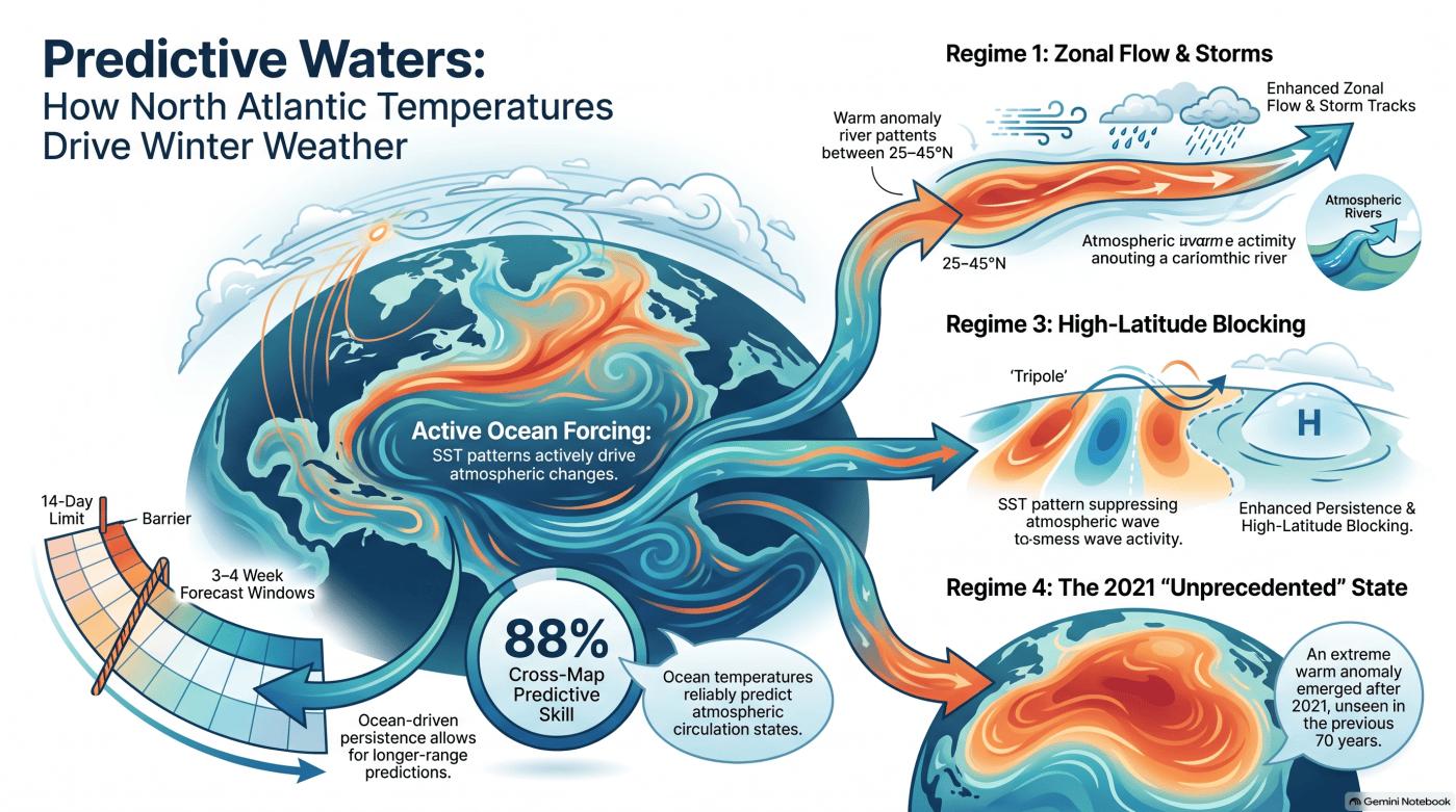
This infographic was generated by Google Notebook.
This blog post and the “Deep Dive” podcast, created by Google Notebook, are based on a preprint article “North Atlantic SST Drives Sub-seasonal Variability and Predictability of the Large-Scale Circulation” by Murphy et al. (2026).
A preprint article by Murphy et al. (2026) investigates the causal relationship between North Atlantic sea surface temperature (SST) and large-scale atmospheric circulation to improve weather predictability. By utilizing nonlinear causal inference and machine-learning techniques, the authors demonstrate that the ocean actively dictates atmospheric patterns on sub-seasonal scales rather than just reacting to them. The analysis identifies four distinct winter SST regimes, including a recently emerged “unprecedented” warm state observed since 2021. Each ocean configuration triggers unique shifts in Rossby wave activity and storm tracks, directly affecting weather across Europe and the Mediterranean. Specifically, certain regimes promote atmospheric persistence, which creates extended “windows of opportunity” for accurate forecasting beyond the standard two-week limit. Ultimately, these findings provide a dynamical framework for using oceanic conditions to better anticipate climate extremes and enhance long-range predictions.
For decades, meteorologists have lived in the shadow of the “two-week wall.” Because the atmosphere is a chaotic system, traditional weather models typically lose their edge after 14 days, leaving us blind to the specifics of the month ahead. Historically, we viewed the North Atlantic Ocean as a passive spectator in this chaos—a mirror that merely reflected the whims of the wind.
However, an international collaboration between researchers at the Hebrew University of Jerusalem, Italy’s Institute of Atmospheric Sciences and Climate, and the University of Trento has just turned that perspective on its head. Their research suggests that the ocean isn’t just a passenger; it is an active architect of atmospheric states. By learning to read the ocean’s “memory,” we may have finally found the key to cracking the subseasonal code, potentially extending our weather intelligence to a three- or four-week horizon. This shift changes our fundamental understanding of weather: what we once dismissed as unpredictable noise may actually be a deliberate response to the heavy, slow-moving hand of the North Atlantic.
1. The Ocean as an Active Architect (Not a Passive Mirror)
To prove the ocean is driving the air, the research team, led by Victor Murphy and Assaf Hochman, moved beyond traditional statistics. Standard tools like Granger causality often fail in climate science because they assume “separability”—the idea that you can neatly isolate a cause from its effect. In the messy, nonlinear reality of our planet, everything is coupled.
The team instead used Convergent Cross Mapping (CCM), a technique based on “attractor manifold reconstruction.” In simpler terms, if the ocean is truly forcing the atmosphere, information about the ocean must be deeply embedded within the atmosphere’s own dynamics. The researchers discovered a profound “directional asymmetry”: Sea Surface Temperatures (SST) contain significantly more predictive information about the atmosphere than the other way around.
“This directional signature is established by the asymmetric way the ocean and atmosphere predict each other; the ocean isn’t just reacting to the wind—it is the hand holding the mirror, actively shaping the atmospheric state across daily-to-subseasonal timescales.”
This is the “smoking gun” for oceanic influence. Because the ocean changes so much more slowly than the air, it provides a stable anchor for the atmosphere. By proving that the ocean forces the air even on short, daily-to-subseasonal windows, the study establishes that the North Atlantic is a primary driver of our weather’s evolution.
2. The “Unprecedented” Arrival of Regime 4
Using machine-learning tools called Self-Organizing Maps (SOM), the study categorized 75 years of North Atlantic winter data into four distinct “regimes.” While three of these patterns have shifted back and forth since 1950, the researchers were met with a statistical ghost: a fourth pattern that had no business existing based on the historical record.
Regime 4 is a coherent, exceptionally warm anomaly stretching along a southwest-to-northeast axis. It is a titan among patterns, boasting a peak temperature anomaly of greater than +3.0°C—more than double the intensity of the other regimes. Most shocking to the researchers was its timing: this state was completely absent for 71 years, emerging only after 2021. It represents an “unprecedented” frontier, a new oceanic state that may be a harbinger of a rapidly changing climate.
The other three regimes, however, provide the reliable blueprint for our current winter forecasting:
| Regime | Structure & Latitude | Peak Anomaly | Primary Atmospheric Effect |
| Regime 1 | Elongated warm feature (25–45°N) | +1.2°C | Boosts “Zonal” flow; steers storms and moisture toward Northern Europe. |
| Regime 2 | Basin-wide cooling (Tropics/Subtropics) | -1.0°C | Weak/fragmented response; causes anomalous ridging over Southern Europe. |
| Regime 3 | Tripole (Warm <25°N & ~50°N) | +1.5°C | Favors “Atmospheric Blocking”; redirects storms toward the Mediterranean. |
3. “Windows of Opportunity” for Extended Forecasts
The most immediate win for the public is the discovery of “windows of opportunity” within Regime 3. Most of the time, the atmosphere is a high-dimensional mess of “options.” However, researchers found that when the North Atlantic enters its Regime 3 “tripole” state, it effectively begins restricting the atmosphere’s choices.
Using dynamical-systems metrics, the study measured the “local dimension” (the complexity of the system) and “inverse persistence” (how fast the weather state changes). They found that Regime 3 creates an environment of enhanced atmospheric persistence. Essentially, the ocean forces the atmosphere into a “slowly evolving” state.
Identifying these windows is a game-changer. When the ocean locks into Regime 3, the typical 14-day forecast limit effectively dissolves, allowing climate services to issue high-confidence predictions for 3- to 4-week lead times. For emergency planners, this means knowing a month in advance if a persistent blocking pattern will lead to a prolonged cold spell or a period of heavy flooding.
4. Pattern Matters More Than Temperature
Perhaps the most counter-intuitive finding is that the shape of the ocean’s temperature matters more than the temperature itself. It isn’t enough to know if the North Atlantic is “warm” or “cold” on average.
For instance, Regime 2—a basin-wide cooling—produces only a “weak and spatially fragmented” response in the air. However, the specific “tripole” of Regime 3 and the “elongated” warmth of Regime 1 act as powerful dynamical pathways. These spatial structures function like steering mechanisms for the great “rivers in the sky.”
- Rossby Waves: Large-scale planetary waves are intensified by Regime 1 but suppressed by Regime 3.
- Atmospheric Rivers: These moisture-laden corridors are redirected based on the ocean’s layout. Under Regime 1, they drench Western Europe and Scandinavia. Under Regime 3, the ocean steers these “rivers” southward, creating a major forecasting win for the Mediterranean, Iberia, and Morocco, which see increased storm activity.
Conclusion: The Future of Climate Intelligence
We are entering an era where “SST regime classification” could be implemented in real-time. By monitoring the North Atlantic’s surface patterns, meteorologists can now identify exactly when the atmosphere is likely to settle into a predictable state versus when it will remain chaotic.
As we move into a future where “unprecedented” states like Regime 4 become the new normal, our survival may depend on our ability to interpret the ocean’s influence. If the ocean is the primary keeper of the climate’s memory, how well are we prepared to read the new, increasingly volatile stories it is beginning to tell?
Murphy, V., Yaniv, R., Lembo V. et al. North Atlantic SST Drives Sub-seasonal Variability and Predictability of the Large-Scale Circulation, 10 August 2026, PREPRINT (Version 1) available at Research Square [https://doi.org/10.21203/rs.3.rs-10535369/v1]


My local data shows a different pattern for this specific region. The long-term trend does not follow the global averages mentioned in your analysis.