
This blog post and the “Deep Dive” podcast, created by NotebookLM, are based on “Abrupt Gulf Stream path changes are a precursor to a collapse of the Atlantic Meridional Overturning Circulation” by van Westen & Dijkstra (2026).
This research explores how abrupt changes in the Gulf Stream’s path act as an early warning sign for a potential collapse of the Atlantic Meridional Overturning Circulation (AMOC). Using high-resolution ocean simulations, the authors demonstrate that a significant northward shift of the Gulf Stream near Cape Hatteras occurs decades before the AMOC reaches a tipping point. These findings are supported by satellite and subsurface temperature observations from 1965 to 2024, which already show a persistent northward trend. The study suggests that the weakening of the Deep Western Boundary Current alters local vorticity, forcing the Gulf Stream to detach from the coast at higher latitudes. Consequently, monitoring these rapid current displacements provides a vital, near-real-time indicator of imminent and large-scale climate shifts. This predictive tool is essential because an AMOC collapse would trigger drastic temperature drops in Europe and disrupt global weather patterns.
1. The Atlantic’s Hidden Pulse
The Atlantic Meridional Overturning Circulation (AMOC) is the thermal engine of the North Atlantic, a vast conveyor belt that dictates the climatic fate of entire continents. In its healthy state, this system moves roughly 17 to 20 Sverdrups (Sv)—where a single Sverdrup represents one million cubic meters of water per second—transporting essential heat toward the northern latitudes. Oceanographers have long categorized the AMOC as a critical “tipping element.” Its collapse would not be a gradual decline but a regime shift toward a state of minimal circulation (potentially below 5 Sv), triggering a valuable piece of information for society: the imminent risk of extreme environmental upheaval, particularly for a Europe facing drastic cooling.
The challenge in climate monitoring is that the AMOC’s most critical movements occur in the deep, invisible reaches of the sea. However, new research suggests that the Gulf Stream—the visible, surface-level branch of this system—acts as a diagnostic signal. Its geographic path serves as a “tripwire,” revealing the deep-sea approach of a climate tipping point through movements that can be observed in real-time.
2. The 219-Kilometer Leap: A Warning from the Future
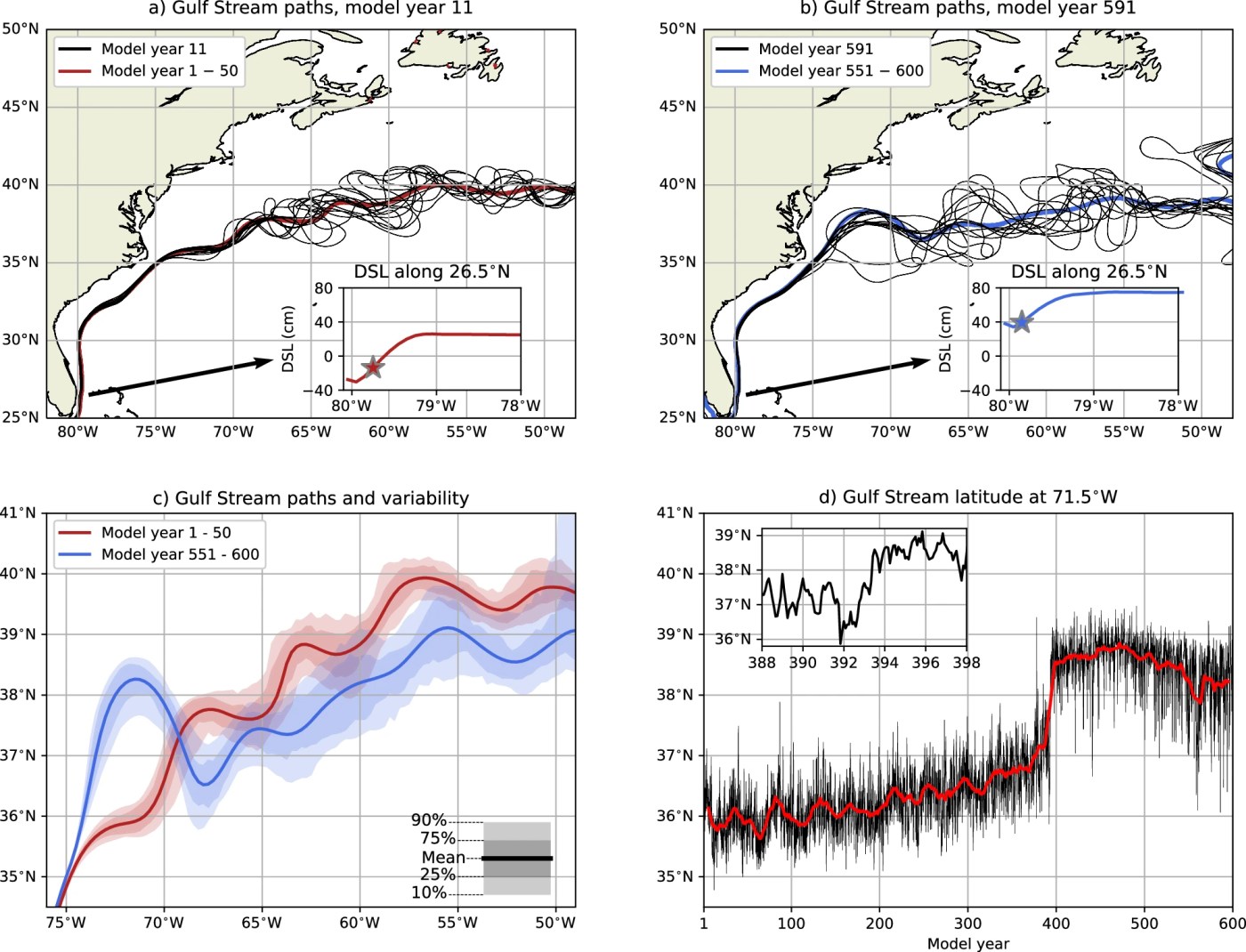
Utilizing high-resolution (0.1°) simulations via the Parallel Ocean Program (POP), researchers have identified a startling precursor to AMOC failure. Near Cape Hatteras, at the 71.5°W crossover point, the simulation reveals an “abrupt northward displacement.” While the Gulf Stream initially shifts gradually, it eventually undergoes a shocking 219-kilometer northward leap within a mere two-year window.
In a system as massive as the Atlantic, a shift of this magnitude in such a compressed timeframe is a total system shock. This leap occurs approximately 25 years before the total AMOC collapse, positioning it as a critical early warning indicator. However, as a senior oceanographer, I must include a necessary caveat: this 25-year lead time is model-dependent, influenced by specific bathymetry and the nature of the freshwater forcing used in the study. In the real world, under the pressure of anthropogenic forcing, the specific window of response may vary, yet the signal remains a robust precursor.
“These findings provide indirect evidence for present-day AMOC weakening and demonstrate that abrupt Gulf Stream shifts can serve as early warning indicator for AMOC tipping.”
3. The Invisible Sabotage: Deep-Sea Vortex Stretching
To understand why a surface current shifts so violently, we must look to the abyss. The Gulf Stream is steered from below by the Deep Western Boundary Current (DWBC). In a stable climate, a strong DWBC interacts with the ocean’s bathymetry at the crossover point, creating “bottom vortex stretching.” This physical mechanism, governed by vorticity conservation, effectively tethers the Gulf Stream to the continental margin through topographic steering.
As the AMOC weakens, the DWBC loses momentum, reducing this vortex stretching and allowing the Gulf Stream to detach from the margin and drift north. This is where model resolution becomes paramount. Standard 1° climate models are far too coarse to capture “mesoscale processes”—the ocean eddies that act as the gears of the current, driving momentum and heat transport. Only at 0.1° resolution do these eddies and the intricate baroclinic effects become visible, revealing how the deep-sea “steering” of the Gulf Stream begins to fail long before the surface current itself disappears.
4. A 6.5°C Temperature Shock
The northward migration of the Gulf Stream is not merely a change in coordinates; it is a thermal regime shift. At the transition point (38°N, 71.5°W), simulations recorded a local temperature increase of 6.5°C in the upper 250 meters in just two years. This is not “warming” in the traditional sense; it is a total transformation of the regional water column.
This jump contributes to a “sea surface temperature (SST) dipole,” where the shift point warms intensely while the subpolar gyre further north begins to cool. Crucially, this warming is exacerbated by the cessation of the Labrador Current. Normally, the Labrador Current advects cold, subpolar water along the continental slope, acting as a thermal barrier. When the AMOC falters, this cooling influence vanishes, and ocean eddies flood the margin with heat. The result is a total engine failure where the cooling barrier is replaced by a surge of subtropical warmth.
5. Evidence in the Now: This is Not Just a Simulation
The most urgent aspect of this research is that the “tripwire” is already being triggered in the real world. Satellite altimetry data (1993–2024) shows a significant northward trend of 0.16°N per decade at 71.5°W (p < 0.05), a finding confirmed by subsurface temperature observations dating back to 1965 (p < 0.01).
Current observations indicate that the daily-averaged path of the Gulf Stream has already reached 38°N. This is a critical threshold; in high-resolution models, reaching this latitude was the final stage before the abrupt 219-kilometer northward transition. While yearly averages show a more gradual trend, the daily peaks suggest the system is testing its limits.
“The advantage of this GS early warning indicator is that it can be observed in near-real time, while other proposed… indicators require much longer observations.”
Unlike statistical indicators that require decades of deep-sea data to reach significance, the Gulf Stream’s path can be monitored via satellite. It provides a real-time dashboard for a system that is historically difficult to measure.
6. Conclusion: Navigating the Tipping Point
The path of the Gulf Stream is more than just a current; it is a real-time monitor for the health of the global climate. We have moved past the era where AMOC weakening was a theoretical concern for the distant future. The data shows the Deep Western Boundary Current is already losing its grip, and the Gulf Stream is drifting into the latitudes associated with a systemic leap.
We are watching the gears of the North Atlantic begin to slip. If the Gulf Stream’s path is our most reliable tripwire, and it is already flashing red, we must ask ourselves: are we prepared to respond to a signal that is no longer a warning of what might happen, but a report on what has already begun?
Figure 2 from van Westen & Dijkstra (2026): Gulf Stream path changes during AMOC collapse. a The monthly-averaged GS paths for model year 11, including the time-mean GS path for model years 1–50. For the latter, first, the time-mean DSL is obtained, and then the GS path is determined. The GS paths are derived from DSL isolines starting at 26.5°N, where the DSL at the maximum zonal DSL gradient is used (the stars in the inset) for the GS path. b Similar to panel a, but now the monthly-averaged GS paths for model year 591 and time-mean GS path for model years 551–600. c The GS paths for model years 1–50 and model years 551–600, where first the time-mean DSL field is obtained and then the GS path is determined. The shading represents the GS path variability using 50 different years, where first the yearly-averaged DSL field is obtained and then the GS path is determined. d The monthly-averaged GS latitude at 71.5°W, including a 11-year moving average (red curve). The inset shows a zoomed-in version from model year 388–398.
van Westen, R.M., Dijkstra, H.A. Abrupt Gulf Stream path changes are a precursor to a collapse of the Atlantic Meridional Overturning Circulation. Commun Earth Environ 7, 197 (2026). https://doi.org/10.1038/s43247-026-03309-1

One caveat is that the northward Gulf Stream shift in satellite data is linked to a strengthening (not a weakening) of the current, often driven by (+) North Atlantic Oscillation (NAO). So, it is too premature to say that the shifting is already happening.