
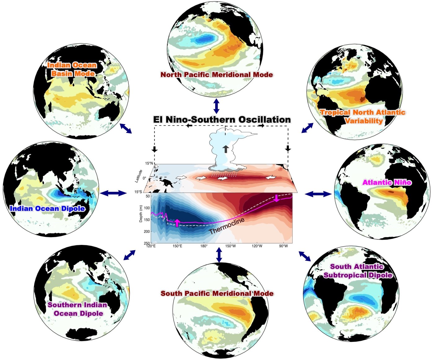
According to the recharge-discharge oscillator theory (Jin, 1997), the leading mode of tropical Pacific upper ocean heat content anomalies is a predictor (or a precursor) for the onset of El Niño – Southern Oscillation (ENSO) at the interannual time scale. A new study published in Nature (Zhao et al., 2024) utilized multiple global sea surface temperature (SST) climate indices, which are known to be linked to ENSO such as Indian Dipole mode (IOD), Atlantic Niño/Niña (ATL3 index), and Pacific Meridional Mode (PMM), to extend the current ENSO predictability from ~6 months to 16~18 months. The authors named this prediction tool an extended nonlinear recharge oscillator (XRO) model because ENSO and the related global climate indices could be considered an integrated global recharge-discharge oscillator.
Although the XRO model is nonlinear and much more complex, the core idea is similar to performing a partial regression analysis using multiple SST indices such as IOD, PMM, and ALT3 at T=T0 to estimate the NINO3 index (an estimate for ENSO amplitude) at T=T1
NINO3 (T1) = a×IOD (T0) + b×PMM (T0) + c×ATL3 (T0) ……
Alternatively, the leading mode of tropical Pacific heat content anomalies and its principal component (HCPC1) at T=T0 can be used to estimate the NINO3 index at T=T1
NINO3 (T1) = d×HCPC1 (T0)
It does make sense that the former has a higher prediction skill than the latter because a large portion of relatively weak ENSO events are known to be forced by remote signals, such as the North Pacific Oscillation (NPO), and are not preconditioned by the tropical heat content anomalies. Now, the real challenge for these authors is to check and verify if the XRO model predicts the evolution of the NINO3 index for the next 16-18 months. What do you think?
Image Credit: Interactions of El Niño with other climate patterns lead to enhanced El Niño predictability by Sen Zhao, UH SOEST. https://phys.org/news/2024-06-el-nio-months-physics-based.html
Jin, F.-F. An equatorial ocean recharge paradigm for ENSO. Part I: conceptual model.
J. Atmos. Sci. 54, 811–829 (1997).
Zhao, S., Jin, FF., Stuecker, M.F., Thompson, P.R., Kug, JS., McPhaden, M.J., Cane, N.A. Wittenberg, A.T. & Wenju C. Explainable El Niño predictability from climate mode interactions. Nature 630, 891–898 (2024). https://doi.org/10.1038/s41586-024-07534-6

Hi Sang-Ki. My main concern right now is how a developing La Niña combined with a warm North Atlantic could impact this year’s hurricane season with low wind shears and higher probabilities of storm development. Below is the heads-up I just sent out to my extended family about the current situation:
“A Cape Verde tropical wave is now showing up on the computer model forecasts (screenshot below). Some time around July 4th it’s projected to most likely be in the Caribbean, due south of Miami. If that pans out, we won’t be affected and it will hit Central America. However, a few of the computer models (less likely) show it crossing over Puerto Rico on a track that could bring it close to Florida. As I said, it doesn’t seem likely that it would affect us but nevertheless we need to keep our eyes on it. Should that worst case scenario materialize (a named tropical storm or hurricane expected to impact Florida around July 5th), then we might need to hunker down. Again, that’s not likely but if it does happen we’ll have plenty of warning and time to prepare. In that event the news media will keep us informed and they’ll outline our options, like how to prepare (e.g., stock up on water and non-perishable foods, etc.) and where the nearest shelter is if we don’t want to weather the storm in our homes.”
>
Hi David,
One thing that I would like to add is that typically ENSO plays a minor role in Atlantic hurricane activity during early season (June-July) because ENSO is usually very weak. But, it develops pretty quickly during the Atlantic hurricane peak season (August-October) and plays a significant role.
https://ocean2climate.org/2022/02/11/enso-plays-little-role-in-early-season-atlantic-hurricane-activity/
So, if the current warm condition in the tropical Atlantic continues and the La Nina develops further, we will see a perfect storm condition for super active Atlantic hurricane season starting from August.
Best,
Sang-Ki
Hi Sang-Ki,
Thank you very much for this post of our paper. I am pleased to let you know we get our XRO model forecast operationally at https://senzhao.netlify.app/climate/xro/. We will see how the XRO model performs in the future. Please check out the latest 18-month ENSO forecast (Nino3.4 index) from 2024 August.
I also have two comments regarding your post:
Happy to have more discussions.
Thanks,
Sen
Thank you, Sen. This La Nina appears to be another multi-year La Nina event according to your forecast. I look forward to reading more about your operational forecast. – Sang-Ki