
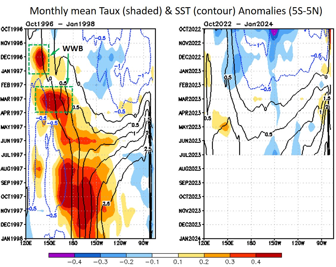
As of July 2023, the developing El Niño in the Pacific has already exceeded its sea surface temperature (SST) anomalies of 1°C in Niño3.4 region (central Pacific) and 3°C in Niño1+2 region (far eastern Pacific). This is the first time to have those SST thresholds exceeded since the development of 1997-98 “supper El Niño” in 1997. During the August 2023 NOAA CPC’s ocean briefing, CPC scientists presented an in-depth look at the developing El Niño in comparison to the 1997-98 event. The 1997-98 El Niño was greatly boosted by a series of westerly wind burst (WWB) events in the spring and summer of 1997. Indeed, all major El Niño events prior to and after the 1998-98 event are characterized by both (1) an active season of WWB events and (2) preconditioning (i.e., warm and deep western tropical Pacific) during their onset and developing phases (i.e., spring and summer). The current developing El Niño has been as strong as the 1997-98 event so far. However, no WWBs have been detected in the western or central equatorial Pacific this year. This means that the development so far has been solely induced by warm water volume accumulation in the western Pacific, induced by the 2020-23 three-year La Niña, and its subsequent eastward propagation through downwelling oceanic Kelvin waves. From now to the winter, warm anomalies in the eastern Pacific will be transported to the central basin by the mean current and very likely produce active air-sea interactions (a.k.a. Bjerknes feedback) to further strengthen the El Niño. So, this El Niño will likely survive and further develop into the winter. Nevertheless, without WWBs reinforcing the developing El Niño during the next couple of months, it is unlikely that it turns into anything close to the 1997-98 “super El Niño”.
Figure (page 16): Evolution of Monthly Mean Zonal Wind Stress Anomaly across [5S-5N] from NOAA CPC ocean briefing (August 10, 2023).
Global Ocean Monitoring: Recent Evolution, Current Status, and Predictions by NOAA CPC https://www.cpc.ncep.noaa.gov/products/GODAS/ocean_briefing.shtml

Thanks Sang-Ki. I expect to see this El Niño mature toward the end of this year as per normal. But the impacts outside of the El Niño coastal region will also depend a lot on how the Atlantic evolves leading up to that. Right now, the Atlantic is warm, competing with the Pacific. But IMO, if the Atlantic cools off while the Pacific warms, I think that’s a recipe for greater climatic impacts on the larger scale. It’s going to be an interesting 12 months into the future. — Dave
>
Hi David.
According to NMME seasonal forecast, the current warm SST anomalies in the tropical North Atlantic (TNA) will remain above 1degC until April 2024 (page 45 in the August 2023 ocean briefing:
https://www.cpc.ncep.noaa.gov/products/GODAS/ocean_briefing.shtml).
As we know well from your paper (Enfield and Mayer, 1997), SST anomalies in TNA usually peak in spring and dissipate rapidly afterward during early summer. So, I am not really sure if I can believe the model prediction. In fact, I have never seen warm SST anomalies in TNA continue into the following winter (I need to double-check that).
Related to your comment, there is also an idea that the current development of El Nino can be suppressed by warm SST in the tropical North Atlantic, and may lead to a very active hurricane season this year (https://www.nature.com/articles/ngeo1686).
Sang-Ki