
This blog post and the “Deep Dive” podcast, created by NotebookLM, are based on “Recent Increasing Trend in October–November Caribbean Tropical Cyclone Activity” by Klotzbach. (2026).
This research analyzes the significant increase in Caribbean tropical cyclone activity during October and November from 1979 to 2024. The authors identify a doubling of hurricane-strength storms and landfalls in recent decades, driven by a warming Atlantic Warm Pool and a shift toward La Niña-like conditions in the Pacific. These shifting ocean patterns have created a more favorable environment for storm development by reducing vertical wind shear and increasing mid-level moisture. Additionally, changes in the African easterly jet have provided stronger atmospheric “seeds” that foster storm genesis late in the season. The study concludes that as long as the Caribbean continues to warm faster than the tropical Pacific, heightened late-season hurricane activity is likely to persist. These trends pose a growing threat to the Caribbean islands, Central America, and the United States, where such storms have recently caused massive economic damage and fatalities.
Traditionally, the arrival of October signaled a time for coastal communities to breathe a sigh of relief. As the “tail end” of the Atlantic hurricane season approached, the assumption was that the worst had passed. However, the data tells a different story for the Caribbean. While only 18% of named storms across the broader Atlantic basin form during October and November, a staggering 53% of all Caribbean named storms develop during this late-season window.
This regional volatility was tragically illustrated in 2020 by Hurricanes Eta and Iota, which struck Nicaragua just two weeks apart at major hurricane strength. These weren’t isolated incidents of bad luck. According to new research by Klotzbach et al. (2026), we are witnessing a “new normal.” In the Caribbean, the atmosphere and ocean have realigned to create a late-season environment that is more frequent, more intense, and more dangerous than at any point in the satellite era.
The Dramatic Doubling of Late-Season Storms
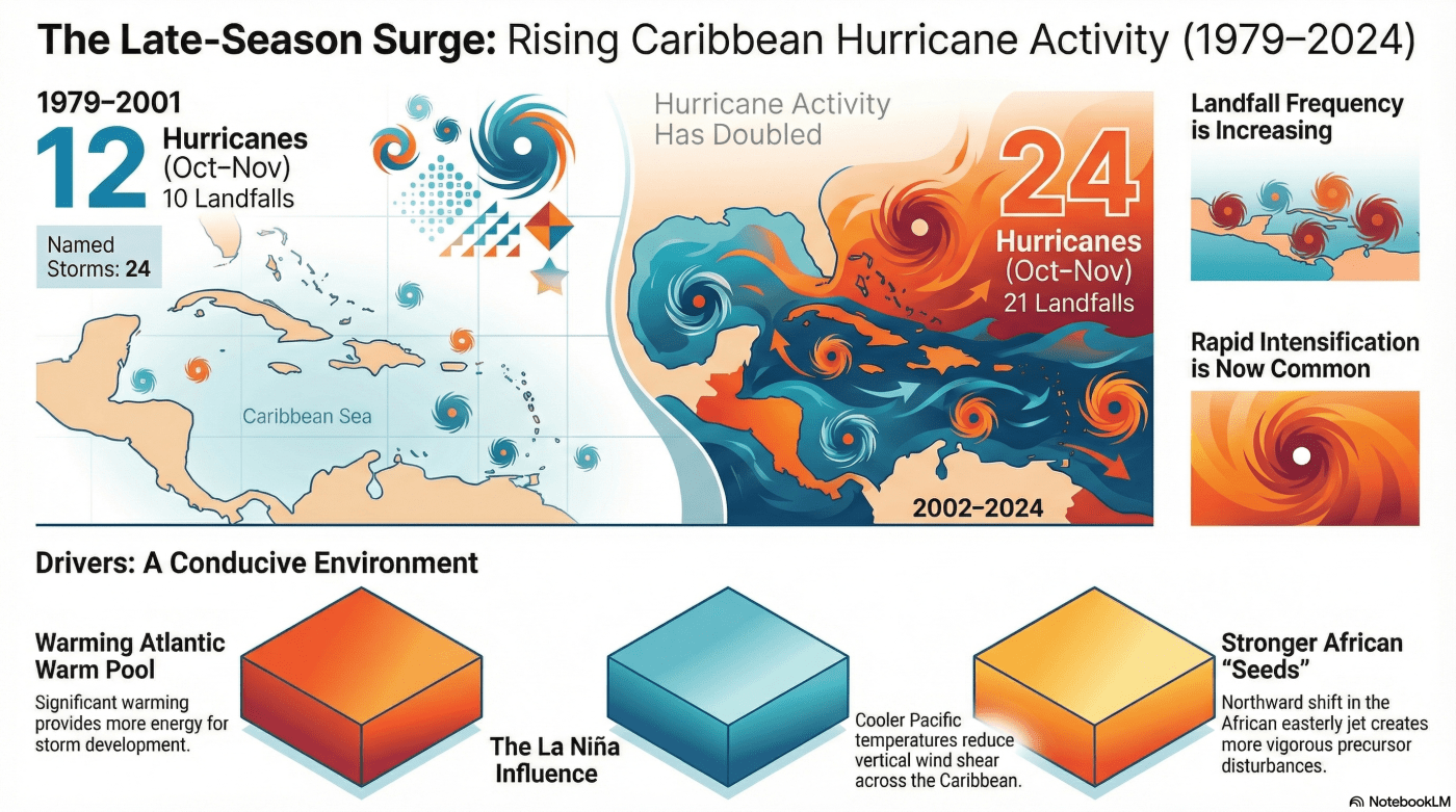
The statistical shift in the Caribbean is nothing short of a transformation. When researchers compared the early satellite era (1979–2001) to the most recent two decades (2002–2024), they found that the number of hurricanes and landfalling hurricanes in the region has approximately doubled.
Crucially, this isn’t an Atlantic-wide trend. The study notes that there is no significant increasing trend for October–November storms in the Gulf of Mexico or the open Atlantic. This is a crisis uniquely focused on the Caribbean basin, where the “seeds” of storms are finding more fertile ground than ever before.
“Caribbean hurricanes are happening more often, hitting land more often, and strengthening more quickly.”
The “Speed Trap” of Rapid Intensification
Perhaps the most harrowing aspect of these modern storms is the rise of Rapid Intensification (RI). Meteorologists define RI as a tropical cyclone’s maximum sustained winds increasing by at least 15 m s^{-1} (about 34 mph) within a single 24-hour window. This phenomenon effectively creates a “speed trap” for coastal residents, as storms can “skip” the preparation window typically afforded by slower-developing systems.
Between 1979 and 2024, 61% of all Atlantic hurricanes underwent RI at some point in their lifespan. In the Caribbean’s late-season window, this trend is especially lethal: every single tropical cyclone that underwent RI in the Klotzbach study reached hurricane strength. Because these storms strengthen so rapidly near land, they often leave local authorities and residents with almost no time to execute evacuation plans or secure property.
A Tale of Two Oceans: The Climate Engine
This surge in activity is being driven by a powerful temperature contrast between two oceans. While the “Atlantic Warm Pool”—the area covering the Caribbean and western tropical Atlantic—has warmed significantly, the eastern and central tropical Pacific have trended toward “La Niña-like” cooling. This creates a teleconnection, where cooling in the Pacific changes the wind patterns in the Atlantic to favor storm growth.
This engine provides the “fuel” for hurricanes by altering three critical environmental factors. A key component is the increase in Potential Intensity (PI), which acts as the “theoretical speed limit” for a storm based on the thermodynamic energy available in the ocean and atmosphere.
- Increased Potential Intensity (PI): Higher speed limits mean storms can grow much stronger than in previous decades.
- Decreased Vertical Wind Shear: The Pacific cooling reduces the crosswinds that would otherwise “rip” a developing storm’s structure apart.
- Increased Mid-level Humidity: Higher moisture levels in the middle of the atmosphere (700-hPa) prevent dry air from choking the storm’s core.
The African Connection: Shifting the “Seeds” of Genesis
While the Caribbean is the destination, the “seeds” of these hurricanes often begin as African Easterly Waves (AEWs). These pulses of energy are carried by the African Easterly Jet (AEJ), a high-altitude wind current. Data shows that this jet has shifted its position northward, moving from an average latitude of 10.5°N to 11.5°N.
This northward shift has increased the “meridional shear” on the southern flank of the jet. In simpler terms, this change in wind structure has led to “increased energy conversion,” allowing waves to become more vigorous before they even leave the African coast. These robust “seeds” are more likely to survive the trek across the Atlantic and blossom into major hurricanes upon reaching the warm, moist environment of the late-season Caribbean.
The Outsized Economic Reality
The human and economic toll of this shifting trend is immense. Smaller nations face a disproportionate burden; for Nicaragua, the combined devastation of Hurricanes Eta and Iota in 2020 resulted in roughly 700 million USD in damage—an amount representing approximately 6% of the entire country’s annual Gross Domestic Product (GDP).
When we look at the broader picture, the stakes become even clearer. Notable storms like Irma, Maria, and Ian have collectively caused over 1,000 direct fatalities and more than 200 billion USD in total damages. As the frequency and intensity of landfalling hurricanes increase in the final months of the year, the window for recovery and reconstruction for these vulnerable regions continues to narrow.
Conclusion: A Forward-Looking Forecast
The “November Surprise” is no longer a surprise; it is a measurable trend. The findings of Klotzbach et al. (2026) suggest that as long as the Caribbean continues to warm at a more substantial rate than the eastern and central Pacific, this era of heightened late-season volatility will likely persist.
As we adjust to a world where the hurricane season no longer effectively ends in September, we are forced to confront a difficult reality. How must we rethink our building codes, our emergency response timelines, and our very definition of “coastal safety” in an era of extended and intensified storm activity?
The infographic was generated by Notebook LM.
Klotzbach, P. J., Silvers, L. G., Bercos‐Hickey, E., Allen, C. J. T., Bell, M. M., Blake, E. S., et al. (2026). Recent increasing trend in October–November Caribbean tropical cyclone activity. Geophysical Research Letters, 53, e2025GL120183. https://doi.org/10.1029/2025GL120183

Leave a comment