
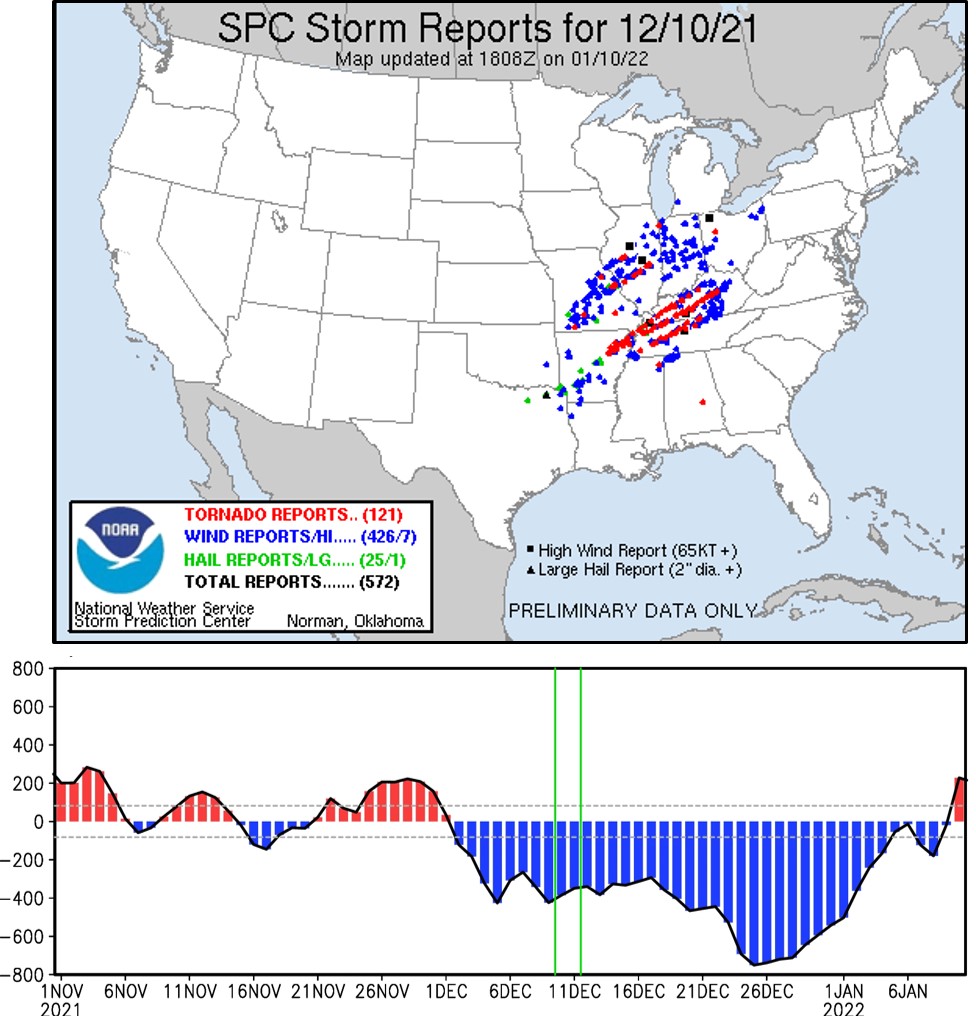
On December 10, 2021, one of the most destructive winter tornado outbreaks developed in northeastern Arkansas. This tornado outbreak, later coined as the Quad-State Tornado Outbreaks by the news media, struck portions of the Ohio Valley, including Missouri, Illinois, Tennessee, and Kentucky, from December 10 to 11, 2021. According to the National Oceanic and Atmospheric Administration (NOAA; https://www.weather.gov/pah/December-10th-11th-2021-Tornado), the Quad-State Tornado Outbreaks resulted in 66 confirmed tornadoes, 89 fatalities, 672 injuries, and at least $3.9 billion in property damages.
A new study published in npj Climate and Atmospheric Science (Kim et al., 2024) showed that the Quad-States Tornado Outbreaks occurred under an exceptionally strong and prolonged negative Pacific-North American pattern (PNA), which developed around December 1 and persisted for a month. This unusual PNA produced a strong atmospheric ridge along the south and eastern US seaboard, which in turn helped warm the Gulf of Mexico and produced large-scale environments conducive for tornadogenesis across the Ohio Valley. The study carried out further analysis to show that a broad region across the Ohio Valley is particularly vulnerable to extensive winter tornado outbreaks during long-lived negative PNA (i.e., persisting longer than 6 days), whereas a limited region in the central US is exposed to winter tornado activity during short-lived negative PNA (i.e., persisting for only 6 days or less).
An important question is if the frequency of long-lived negative PNA will change in the future. According to several previous studies, the amplitude of PNA is projected to increase partly due to the increasing variance of sea surface temperature anomalies in the tropical Pacific in the future, while the frequency of PNA is not expected to change significantly. However, it is still unclear whether the duration of the PNA will change in the future climate. Addressing this question could potentially help achieve a useful forecast capability for future winter US tornado outbreaks.
Image Credit: The upper panel shows the SPC storm report for December 10, 2021 (https://www.spc.noaa.gov/exper/archive/event.php?date=20211210). The lower panel shows the time series of daily PNA index from Nov/01/2021 to Jan/10/2022 (Fig. 1d in Kim et al. (2024)). The black dashed lines in the lower panel are the thresholds of positive and negative PNA events. Green lines represent the period of the Quad-States Tornado Outbreaks (Dec/10–11, 2021).
Kim, D., Lee, SK., Lopez, H., Jeong, JH & Hong, JS. An unusually prolonged Pacific-North American pattern promoted the 2021 winter Quad-State Tornado Outbreaks. npj Clim. Atmos. Sci. 7, 133 (2024). https://doi.org/10.1038/s41612-024-00688-0

Interesting, Sang-Ki, thanks for sharing. While I’m no expert on tornado formation, my general understanding is that they are normally confined to the trans-mountain region of the Midwest, where warm-humid air from the Gulf of Mexico clashes with cool-dry subarctic air from Canada. Is that a fair description of the “normal” pattern? So then, this negative PNA set-up alters this in a way that moves (or perhaps, expands) tornado formation farther to the east? I’ve been wondering about this, based on I see daily on the TV weather reports & outlooks.
Nice hearing from you, — Dave
PS: As you may or may not know, we have recently had a lot of record flooding in parts of coastal South Florida, but not specifically in the area where we live (fortunately). Governor Ron DeSantis doesn’t want to discuss it in terms of climate change and declares that climate change doesn’t exist. To alleviate their concerns, I have written to my extended family here about this as follows:
Hi David,
Good to hear from you. I also thought about that a lot. While a short-lived PNA seems to directly increase the Great Plain Low-Level Jet (GPLLJ), a long-lived PNA seems to produce anomalous low-level jet toward the Ohio Valley. However, I don’t see a reduction of the southerly GPLLJ during a long-lived PNA. So, it is not an eastward shift of the low-level jet, according to this study. But, during some tornado outbreak seasons (e.g., 2011), tornado activity was below-normal in the Great Plain area.
I know someone carried out an EOF analysis of the North American low-level jet to find the first mode describing the GPLLJ variability and the second mode describing eastward shift of the low-level jet. So, I guess these two modes are statistically somewhat independent.
Another important thing to consider is that PNA is not weather. It only provides background atmospheric environments prone to extreme weather outbreak. So, it cannot be used as a prediction tool for daily weather, although it is a useful tool for week-2 (days 8-14) probabilistic forecast.
Your P.S. message was cut off. But, I think I received your email about the sea-level rise earlier. Hope to see you soon.
Best,
Sang-Ki